Sunday, March 31, 2013

White Lined Sphinx Moth


Up at Massai point in Chiricahua National Monument , there is a short half mile interpretive nature trail where you can learn all kinds of things about the flora and fauna of region. As we hiked the trail, we noticed some flowering Pointleaf Manzanita bushes and spotted, what we thought was a hummingbird.  So we trained our binoculars and my camera on it and....

No.  It was a White Lined Sphinx Moth.  It is sipping through its probiscus.  I had my portable hummingbird camera kit set up with the 70-200mm and 2X extender on the 5D3 camera body.  Shooting at 1/2000 exposure f5.6 so the wing is a little blurry.

Click on any of these to see a larger version


Thursday, March 28, 2013

Sunny Flat Campground in the Chiricahua's - This is the place!!

The Chiricahua's are pretty special. Granted, so far we have yet to spend a night in the actual mountains but the is our first.  We arrived 3 days ago out in the valley in Rodeo east of the mountains.  Dry, windy, warm.  we drove into Cave Creek Canyon in search of birds and found a campground called Sunny Flat which appeared large enough to accomodate Charli our RV.  We had already committed to the Rusty's RV park for 3 nights and had a lot of internet and Skype calls to make so decided that on Thursday morning, while I did business and phone calls, Sraddha would go out and scout for potential campsites that might be available. Sure enough, she came back around 11:30 just when I had finished my last call, to say she found a spot.  So we did some laundry, packed up and headed into the canyon.


View of Chricahua's from our RV campground eastside
I drove very slowly on narrow roads up the canyon and found Sraddha waiting for me to guide in the RV. A hummingbird greeted her and we knew this was the spot.

Our campsite

And here we are.  wow.  amazing place.  looking forward to exploring.

Our Back yard

Our Front Yard

We got set up and just sat outside marveling at the scenery.  Truly one of the best campgrounds we have ever seen.  Dinner was served outside and we counted our blessings.

No internet or running water however, the location is truly a five star experience.


Dinner with a view.

- blessings from the road

Tuesday, March 26, 2013

Bisbee Part II

We had heard of a really cool old time area and a very creative, original RV park nearby so we drove Mr. Toad (the jeep) east down the hill past the open pit mine to find a really fun area of BIsbee called Lowell.  At one end of the main street was an old grocery store converted into a food Co-op where we shopped for some goodies.  The main street had all kinds of old time gas station pumps,  storefronts from the 40's and cars.  I spent an hour photographing with the big camera and will post more later on that.  Here are some pix from my iphone

Notice the signs and old Greyhound bus

This Indian set a land speed record of 140 mph on bonneville salt flats.
Remember the movie, "The World's Fastest Indian"?

Shady Lane RV Park filled with vintage trailers set up as a motel

Of the many fun things to do in Bisbee is walk the Bisbee 1000.  Here is the map of the 5K walk (or run for some) that is used in October for their event.  We had it open on iphone to see route.  We walked about 700 of the steps but didn't complete the route due to darkness.  I noted where our RV park is in lower right and also the top highest point from which I shot the photo below.  Was really fun.

5 K walk isn't bad.  Glad we live at elevation because bisbe starts at 5160 ft

one of the stairs.  to the highest point.  you can see 5 on map above

here we go.  whew

Creative metal sculptures masquarading as fence

View from the Top.  you can see our RV way down on middle right if you squint.

Bisbee Part 1

For us, as RV'ers the really neat thing about Bisbee is the RV park right next to Queen Mine and overlooking downtown Bisbee.  Several years about we had driven through Bisbee but spent no time here. (Ask Sraddha about this one).  Anyway we originally intended to spend one night and ended up spending 2.  We were able to walk around the town enjoying the unique creative, architecture and hills.  Glad we live at elevation in the Village because we climbed a lot of steps and made it through.  Here are some pix.

Our back yard - The open pit copper mine

A creative take on downtown retail store.  Wonder what is inside?

In the middle distance is our RV park

Our Front Yard at RV park. Downtown Bisbee in background
Next to RV park is the Queen Mine.  Daily tours are conducted by former miners so we took the undergound tour that goes back 1500 ft into mountain.  Quite fun and informative.
getting dressed for trip underground.  Quite the fashion hound!
 Did you know this mine produced 8 billion pounds of copper during its life.  Shut down in 1975 due to copper prices, there is talk of re-opening.  Also produced 2 million pounds of gold.
Interesting bicycle undergound for shift boss to ride around
 The miners were quite inventive and humorous.  The carts were never on level ground.  they used little blocks to hold in place.  Imagine some prankster......
And you can guess what this is for right?


Patagonia to Bisbee

Driving through Southeastern Arizona you are struck with amazing grasslands.  Did you know the movie "Oklahoma" was filmed here?  Neither did I.  Unfortunately I didn't take pix.  sigh

We took a backroad to Bisbee from Sonoita which the AAA map said would go through but turned into gravel so we had to unhook, turn around and rehook the toad.  Fortunately, my model railroad operating skills were handy here in figuring out the best way to do it in a narrow road.

Our new "detour then took us, so the sign said, to Fort Huachuca.  We thought the city, but nooooo, the back gate to the military installation.  Gulp.  We smiled at the guards and asked if we could just pass through.  "Show me some ID" she said, upon which we produced our Driver's licenses.  She eyed me again.  I took off my sunglasses and smiled. (Thinking, I am not a terrorist am I?).  The guards allowed us through.  "Just stay on main road and you will find main gate.  Little did they know.....

We drove until we came to a round about and saw the sign to main gate.  But Jeeves, our GPS wanted us to go straight through so we did.  Second big mistake.  (first was trusting the AAA map for back roads).  We kept driving but came to a blocked road.  Some event was being set up for motorcycle jumps so the east gate was closed.  What to do?  Jeeves couldn't find main gate.  do we retrace?  first we have to get turned around.  not easy sometimes.  In process we asked some soldiers.  "Gee we aren't allowed off base so we don't know."  Oh great, then after a little conference he told us some directions which we tried but ended up in a dead end.  another turn around. We thought we saw a frontage road down past the main blocked road so we went back down there.  Picture a big motorhome towing a jeep just driving around the base with impunity.  We kept expecting the MP's to come haul into the brig at any moment.  Never happened though.

We made the frontage road and proudly drove to east gate only to find it closed (again for the aforementioned motorcycle demo). but, as we drove past, we spied a sign that said Main gate to the right.  Another turn around.  Yep, this appears to be the correct route.  following a couple other cars who did the same thing, we finally made it out of the main gate and were on the correct road!  Whew.

We drove 6 miles out of Sierra Vista to San Pedro Riparian National Conservation Area along the San Pedro river where we stopped for lunch and explored a little.  After lunch we continued to Bisbee.  What was originally planned as a 2 hour leisurely trip turned into 4.5 hours of wrong turns and turnarounds but still it was fun.

Friday, March 22, 2013

Patagonia Lake State Park


Here in Southern Arizona a few miles north of the Mexico border we are at 3800 ft altitude.  Spring is trying to spring out but not quite yet in most areas.  And the birds are beginning to migrate through.  4 hmmingbird species which will grow to 11 by sometime in April when Spring is really sprung.  We, however will be other places by then.
Among the reasons to visit this area, in addition to its beauty is the birds, the birds, the birds.  Where is Tippi Hedren when you need her?
I have already posted about the main reason to be here, Mr. Elegant Trogan, so I thought to post a few more pix of Patagonia lake park and then will post a few more bird pix even though many of you have seen those pix on Flickr or Picasa.
Driving into Patagonia State Park requires an 11 mile drive out from Nogales, then another 4 miles drive over hill and dale down into the park.


About 85 campsites are filled with families and birders at this time of year.  Later on in spring and summer, we are told, the place turns into party central with the younger generation who are footloose.  We are grateful that we are here now.


 Mondays, Wednesday and Friday mornings at 8 AM, birders convene at the eastern trailhead to head out in search of the elusive Trogan and other birds.  Sraddha went out Wednesday morning on the walk and saw about 60 different species in 3 hours.  The next morning she took me on a walk when we saw the Trogan.  I watched for a bout 20 minutes then had to head back to RV for a conference call while she spent 3 hours following him and came home with a feather. Way cool.
Our campsite is down near the water, however, it happens to be near the waste water treatment plant.  We didn't know when we booked it and it is fine, except in the afternoons/evenings when "eau de waste" wafts up the hill.  Not real bad but just enough, so we stay inside then and eat our dinner instead of enjoying the evenings outside.


Our 10 nights in Tucson area was fun but very packed with activities and great friends. We are here for 5 nights of true R&R, then off east to explore some more.


Location:Patagonia Lake Rd,Nogales,United States

Thursday, March 21, 2013

The Elegant Trogon

The Elegant Trogon spends most of its time in Mexico and migrates up to Southern Arizona to breed in the mountain islands near Nogales, and Patagonia, Arizona. Only easy place to spot it is around here at this time of year. It is about the size of a parrot and weights about 2 pounds. Hard bird to find but I really "lucked out" this morning about 1.5 mile from campground.  Had to wade across some shallow muddy streams, however it was worth it to get this photo. Filled my zoom lens easily and we watched it for 10 minutes. Sraddha is really happy to see this bird for her life list.


Latest Picasa web album with all our 2013 Southwest photos here

Monday, March 18, 2013

Ananda Tucson

We visited Ananda Tucson for Sunday service yesterday. Really sweet.


Much has been done with landscaping out front both mear the street (see above) and inside the front yard. See below.


Christine lead Sunday service in the center.


We took Stanley with us. Wonderful to connect with everyone.

- blessings from the road

Location:1002 e prince road, Tucson, AZ

Tuesday, March 12, 2013

Wandering around Catalina State Park

Most of you, Who have followed this blog for some time, already know that Catalina State Park Is one of our favorite camping grounds and destinations in the southwest.


We arrive Saturday amisdt showers and rains having experienced torrential downpours the night before. Cold weather kept us from exploring. So now as the weather warms up, We are really getting out and enjoying the walks.


Yesterday was spent shopping for some items we needed to get along the way, visiting a good friend, and we finally made it back at the end of the day To hike one of our favorite walks or more like a stroll, the Sutherland Trail.


The golden hour Of sunset greeted us as we walked up the stream bed seeing reflections off of the distant Catalina Mountains.


Hiking up the trail to the plateau we were greeted with the sunset and were able to take this picture of us and you can see It is a blissful experience.

Fortunately we had cell service and on the way back on the hike back I was able to do a FaceTime communications with one of my good friends at back home at the Village.

After all this is 2013.

- blessings from the road

Location:N Oracle Rd,Tucson,United States

Sunday, March 10, 2013

Catalina State Park

We arrived mid Saturday.

Set up camp and walked around enjoying the sunset.


This morning after the rains, our neighbors decided to take a ride with their Airdale dog. Cool BMW with sidecar. Spouse and dog fit in easily.

- blessings from the road

Friday, March 8, 2013

Marathon drive today

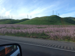
We made it to Buttonwillow by 10:15AM. Nice to get an early start.
After a sumptuous feast if plantains and cabbage ( pupusas) and Orchata rice drink at our favorite Salvadoran restaurant, we checked the weather radar and road conditions. Passes were open but the storm still up in Tehachapi and the Mojave. My inner voice told me to head up the grapevine. Last time we did this we got stuck in LA traffic so I prayed that we made right decision.
Slow news day in LA.
As we drove thru the grapevine across Tejon pass I noticed 3 network news trucks up on the overpass.
Whhaaatt ??
The roads were dry and 1-2 inches of snow on the hills nearby.
Noon news mist be slow. I don't have a Photo because I was driving.
We sailed thru Pasadena ( sight if last years delays) despite showers and rain. All the way out the 210. Stopped at a Starbucks thanks to their iPhone app and switched drivers.
We drove through Riverside area in a downpour, but once we entered the Palm Springs area sun came back out.
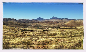
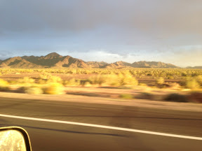
The past times we drive across this part if Mojave it was dark. This time we enjoyed the stark dry desert with creosote bushes, ocatillo and brittle bush.
Blythe, CA, along the Colorado river sports lush green fields and surprised us its size. Last year we stayed in a motel arriving and departing in the dark. Dark clouds filled the eastern horizon with the western sun brightening many surrounding features as it set in the west.

We crossed the Colorado river intending to fuel up with much cheaper gas but soon discovered a long, long line at the pump, so we decided to venture on a few more miles to Quartzite, home to thousands of winter snowbirds boondocking in their RV's.

Gas was even less on quartzite.
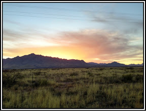
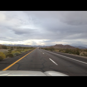
Light here in Arizona is so different than Cali or New Mexico. Not sure why but we sure appreciate it.

Glad we pressed on because we were treated to a lengthy series of lightening flashes on the eastern horizon as we drove on towards Phoenix. Thunder clouds gathering in the east foretold a big energy building over the valley of the sun.
Through the driving rainstorm we pressed on to Tempe to our hotel. Had to search around for last minute for a reasonably priced room since we were uncertain of how far we could drive today.
The heavy downpour continued as we arrived at 8:30 PM. Because the parking lot mostly full we had walk a bit in the rain to the room, but the room had the space to store my bike.
Whew. 13 hours on the road today. We will sleep in tomorrow morning.
- blessings from the road

Location:I-10 E,Salome,United States

South to Arizona

Dawn Found us walking out of the Starbucks in Auburn having got my first cup of Joe for the day. We breezed through Sacramento Stockton. Spring in California is always beautiful with Greenhills and all of the almond and various fruit trees budding out here are a couple examples.


What looks like a nice beautiful day is about to turn into a real fun experience as we drive south. The grapevine and to hatch a P Rd. southbound over the south end of San Joaquin Valley are closed due to snow.

We will stop in Buttonwillow just west of Bakersfield and eat at our favorite restaurant Salvadoran restaurant Tito's Pupuseria, and wait to see if the mountain passes open up.
We hope that By middle of the day, When the temperature rises to about 40°, that the roads will be passable we can get over the hill down into the Mojave and out in the eastern part of Southern California before dark.


- blessings from the road

Location:I-5 N,Patterson,United States